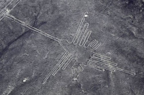
The Nazca Lines are neither extraterrestrial landing strips nor an astronomical calendar. So what are they?
They are ceremonial sites. According to the archaeologists, creating the lines, for example with the use of ranging poles, was part of the cult.
What kind of cult was this?
In some places in the Nazca region, archaeologists have discovered not only altar-like platforms with sacrificial offerings, but also Spondylus shells originating from the warm waters of the Pacific off Northern Peru. Towards the end of the Nazca era, starting around 300 AD, the climate became drier and drier. The desert border shifted towards the East, the Atacama Desert expanded. The shells indicate a water and fertility cult.
Were these climatic changes towards the end of the Nazca culture your part in the research project?
Yes. We conducted some geo-archaeological research with geophysical methods, but the main focus was on the relationship between the Nazca culture and its environment. Initially, archaeologists and some earth scientists had presumed that it was catastrophic rains caused by the El Niño phenomenon that caused the culture's downfall. This makes little sense, however, because then the geoglyphs would have been washed away too. Cahuachi, for example, located 20 kilometres west of Nazca in the middle of the Atacama Desert, used to be a major centre of Nazca cultural life. The question that thus arose was: Might it be the case that the desert was not in fact a desert back then? In 2002 I discovered small island-like deposits of loess more than 50 cm thick. Loess in desert regions usually indicates that the climate used to be more humid there. It can only form if plants of some kind prevent it from being blown away. That was the key. A dating of the finds in cooperation with Prof. Wagner of the Archeometric Research Department showed that open grassland was predominant there between 9000 and the third millennium BC. Monsoon rains from the Andes used to reach much further into the desert than they do today, enabling cultures to emerge and flourish on the eastern border of the desert. During the region's subsequent desertification, the vegetation disappeared again and from the third millennium BC the people retreated to the oases along the rivers, which carried enough water from the mountains each summer.
What did this mean for the population?
Living this close together, the people were forced to be innovative — hunter-gatherer tribes turned into more complex societies. They developed irrigation, for example, and the division of labour; priest castes and sovereigns emerged; pottery was invented. Until the middle of the Nazca period, around 300 AD, conditions remained stable. During the summer, water from the mountains filled up the rivers and wells. But then rainfall became unreliable even in the mountains and longer droughts followed. The people moved further and further into the Andes, where the rains were more regular. Around 650 AD, even these settlements disappeared.
And the dry climate of the desert has preserved the geoglyphs to the present day?
Yes, though starting in the 11th/12th century, the climate became quite humid again, as far as half-way into the desert. In the 16th and 17th century, the Spanish settlers built large basilicas there before the climate became dry once more. It is important to understand that desert borders react quite quickly to variations in rainfall and humidity. Climate and weather are far from fixed. During the warmest period of the Holocene, 6,000 to 8,000 years ago, the Sahara Desert was completely green.
What does this mean for our future?
The current climate models can only provide viable forecasts if they are able to represent the past correctly. Looking back, we find many indications that global warming will lead to a more humid climate in most of the earth's dry regions. During global cold periods, on the other hand, the earth's deserts have always expanded.

For the first time, a group of scientists led by Markus Reindel, an Ancient American Studies specialist from the University of Bonn, have devoted themselves to the mysterious Nazca Lines in Southern Peru. Geographers from Heidelberg were part of the team. Their task was to reconstruct changes in climate and landscape in the region over the past 11,000 years. This way, some light has at last been shed on the purpose of the famous geoglyphs, enormous drawings on the ground. In an Interview, Prof. Bernhard Eitel of the University of Heidelberg's Institute of Geography revealed the mystery of Nazca lines.


